Other than drinking and discussing the wines, there’s nothing so valuable as looking at maps to try and find that elusive vineyard. Perhaps it is only Piedmont that comes close to to the diversity of vineyards found in the Côte d’Or.
Google Maps is an obvious good reference, and the quality of the zoomed-in images is much higher than was once the case.

New, as above, and via the BIVB in March 2020, is this site. It works fine on my desktop – integrated with locations of domaines too, etcetera. It still needs a bit more work for handheld devices I think – a more app-style would be interesting – but it’s a good start 😉
BOURGOGNE MAPS

Then there’s this, the French Government ‘GEOPORTAL’ if you want to delve into the vineyards at a parcel-level – no names to find behind the parcel numbers though. Compared to the BIVB map site (above) you can actually save ‘views’ that you like by noting the URL – it changes – unlike for the BIVB site.
Here for a very long time (2004!) are some maps of the Côte d’Or appellations:
With the exception of a map of Volnay, all courtesy and copyright of Kobrand Education this table is a super ‘cartographical resource’ for which I offer them and the artist Michael Juhn many thanks.
The maps are in PDF format, and most are less than 100kb in size – and YES – I know that there are lots of mistakes, the comments on that in this page are numerous – but clearly the commentors didn’t read this – eh? But they were given free: ![]()
![]()
 |  |  |  |  | |||||
| Aloxe | Auxey | Beaune | Chambolle | Chassagne | |||||
 |  |  |  |  | |||||
| Flagey | Gevrey | Marsannay | Meursault | Morey | |||||
 |  |  |  |  | |||||
| Nuits | Pernand | Pommard | Puligny | Santenay | |||||
 |  |  |  |  | |||||
| Savigny | Volnay | Vosne | Vougeot |
Also of interest…
Linked with their ownership of Louis Jadot, Kobrand also offer here a rather nice webpage that allows you to navigate through maps of the Côte d’Or.
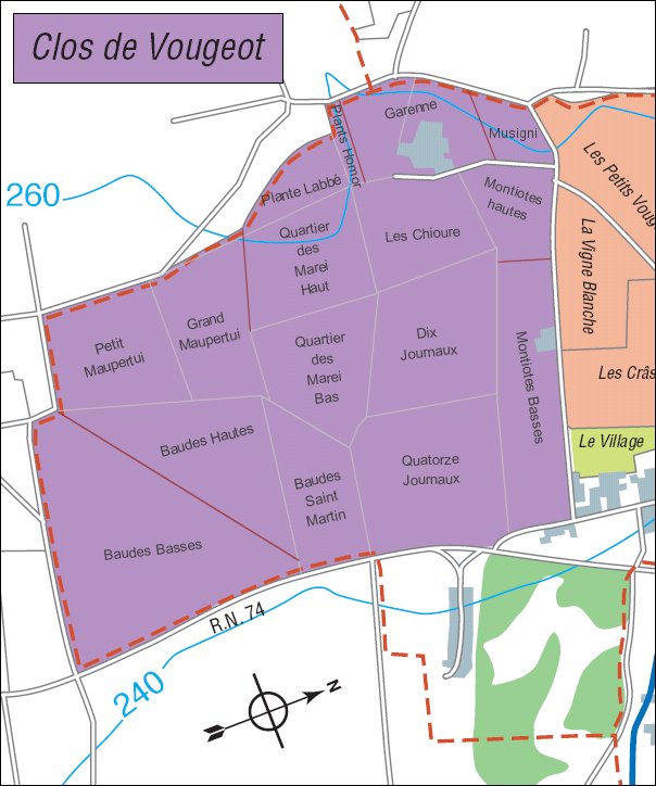
- Here’s a more in-depth look at the Clos de Vougeot (80kb).
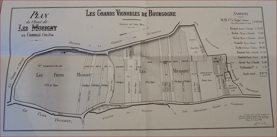
- An 1890 map of the Musigny vineyard and it’s ownership (100kb).
- Burgundy 1640. You need to look in the top left hand corner for ‘Nuis’ (850kb)
- And something a little younger, from Pouilly-Fuissé (494kb)
And Beaujolais?

These maps were newly minted at the end of 2015 and are offered here courtesy, and with the permission of, Inter Beaujolais who are the copyright holders.
Note that the files can be between 9 and 16 megabytes – they will not download in ‘flash:’
There are 14 responses to “07. The map resource”
Bill,
I have one word: Volnay! Why is it that Kobrand and indeed most other resources have no map of this wonderful village? There is one at http://www.bivb.com, but it isn’t very detailed…
I do have an old one Mike – I’ll get it online as time permits!
Cheers
Hello Bill,
Did you notice that the colours of the maps do not correspond to the legend?
I wanted to use some of the maps but I have to copy them into paint and repaint them.
Cheers,
Cristina
Hi Cristina,
Hope you’re well. Yep, lots and lots of mistakes/errors on the maps I’m afraid – that’s what you get for ‘cheap’ – or in this case free!
Bill
GREAT Resource….
Thanks for the time it took to put this together!
Where is Premeaux? A significant amount of Nuits St georges seem to be missing (clos de la Marechale…) or have I missed something?
You’re not missing anything Antoine, the provider of my maps simply didn’t have one for Premeaux – indicating they didn’t have a lot of wines from that village 😉
About : Gevrey-Chambertin map
Legend is wrong :
Gevrey-Chambertin Grand cru must be Gevrey-Chambertin
Gevrey-Chambertin must be Gevrey-Chambertin Grand-Cru
I will have to disable the comments here if everybody wants to keep telling me about the mistakes on maps that I already said have mistakes in 😉
[the maps are somebody-else’s copyright…]
There is a selection of maps as PDFs on the Official ‘Burgundy Wines’ website which I find useful- although still no Premeaux that I can see, Volnay is available.
The title page can be found here:
http://www.burgundy-wines.fr/find-out-about/and-their-wines/their-wines/their-wines,216,157.html?
Hello,
Another useful resource : http://www.geoportail.fr. Type in for instance “vosne-romanée”, and then chhose among different “couches” (layers) :
– “IGN” is a helpful one if you want to plan a bike ride in the vineyards, or check the altitudes, or the name of a river, etc.
– “geologie” is based on a larger scale, but quite useful as well, for instance if you’re pervert enough to check whether this Chablis is on kimmeridigian, or portlandian (as it should NOT be).
– “Cassini layer” is fun too since it provides maps from the XVIIIth or XIXth century.
– “cadastre” is : who owns what ? No name given online but you see the size of the properties.
Personnaly, I find it interesting to combine IGN + cadastre in order to check the real exposition of a terroir.
it’s free, enjoy !
Now that’s cool! The IGN vineyard labels are not always in the correct place, but very cool indeed!
Thanks Florence!
Addendum to my latest post : another useful resource : Maison Bouchard Père et Fils has designed a nice Google Earth map of their numerous properties, to be used at http://www.bouchard-pereetfils.com/google/domaine_fr.php.
Since they’ve identified their own vineyards (mostly in Côte de Beaune of course), it’s a good way of having a 3-D vision, for instance, of the Corton hill and their own Corton vineyard.
In the same range of 3D animation, La Chablisienne has also, for Chablis, a nice and short movie to be seen on their website. It is commercially oriented but that allows viewers to get a good glimpse of the Chablis subtleties regarding Northern orientations, for instance !
Thank you for a very good and informative site on my favourite wine region. Looking through your very good maps, I can’t help thinking that the map of Gevery-Chambertine must have some sort of mix-up in the colour coding. Generic Gevrey and Grand Cru must have been mixed up.
Kind regards,
Øyvind,
We are in Beaune this week, arranging biking expeditions. These maps are a great help. Thank you!
Bill, Just noticed on the Gevry Map that the legend is back to front, Ie the GCs are labelled as Village…thought you might like to know and amend. 🙂
Always was, David, always was 😉
i love the maps, but in Gevrey i think teh coding might be off. It shows GC as lime green, as opposed to the purple. The whole site is great.
Hi bill, great website with lots of excellent information. Just looking through the maps of the villages and noted that the chassagne Montrachet key is mixed with grand and premier cru. The key says grand cru is purple when on the map it is orange/ beige. Just thought you might want to know but as I said excellent website, we have a house in meursault and visit most months, fantastic place to live!!
Best Stuart